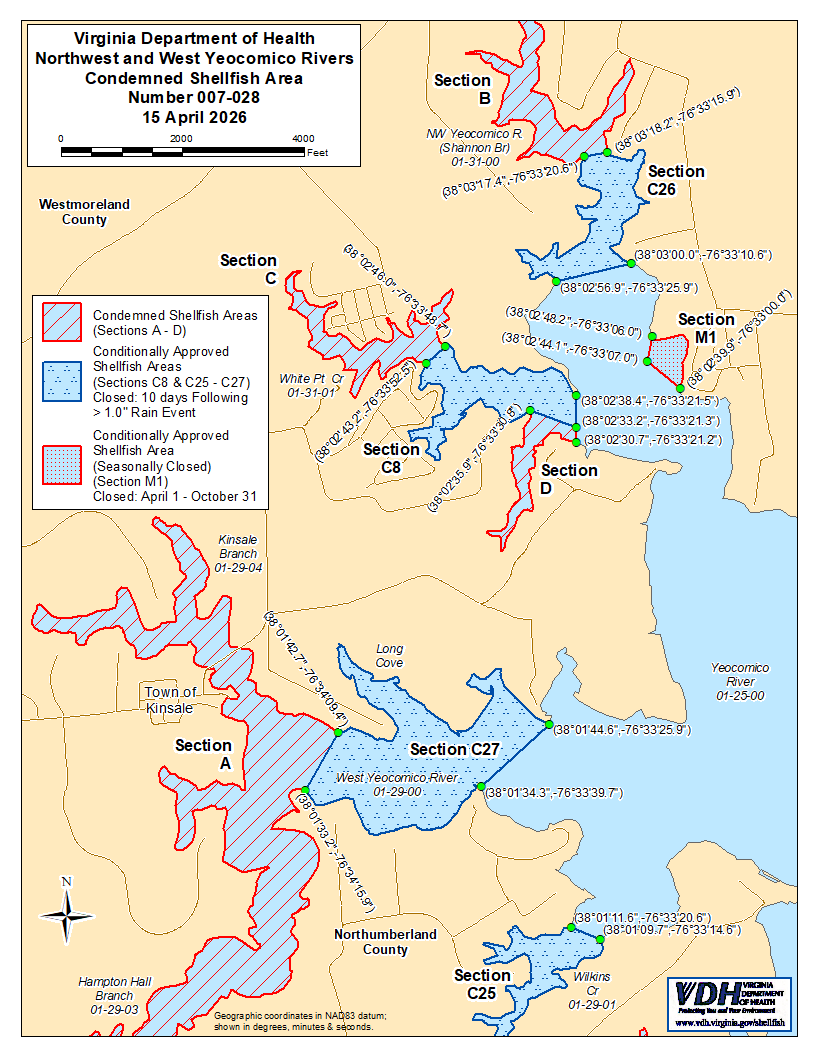
PAUNAWA AT PAGLALARAWAN NG KONDEMNASYON NG LUGAR NG SHELLFISH
BILANG 007-028, MGA ILOG NG NORTHWEST AT WEST YEOCOMICO
MAGKAKABISA SA 15 NG ABRIL 2026
Alinsunod sa Pamagat 28.2, Kabanata 8, §§ 28.2-803 hanggang 28.2-808, § 32.1-20, at § 2.2-4002, B.16 ng Kodigo ng Virginia:
1. Ang “Abiso at Paglalarawan ng Pagkumpiska sa Lugar ng Shellfish Numero 007-028, Northwest at West Yeocomico Rivers,” na may bisa mula 15 Abril 2025, ay kinansela na may bisa mula 15 Abril 2026.
2. Ang Condemned Shellfish Area Number 007-028, na ipinapakita bilang mga Seksiyon A hanggang D, ay itinatatag dito na epektibo sa 15 ng Abril 2026. Ipinagbabawal sa sinumang tao, kompanya, o korporasyon ang kumuha ng shellfish mula sa mga lugar na ito para sa anumang layunin, maliban kung may pahintulot na ipinagkaloob ng Marine Resources Commission, gaya ng itinatadhana sa § 28.2-810 ng Code of Virginia. Ang mga hangganan ng mga lugar na ito ay ipinapakita sa mapa na may pamagat na “Northwest and West Yeocomico Rivers, Condemned Shellfish Area Number 007-028, 15 April 2026” na bahagi ng abisong ito.
3. Ang Condemned Shellfish Area Number 007-028, na ipinapakita bilang mga Seksyon C8 at C25, C26 at C27, ay itinatatag dito na may bisa simula 15 Abril 2026. Alinsunod sa § 28.2-808(3) ng Code of Virginia, ang naturang kondisyonal na pagbabawal ay nakabatay sa mga mahuhulaang pangyayari ng polusyon na nagmumula sa labis na pag-ulan. Ang lugar na ito ay ilalagay sa saradong katayuan sa 12:01 n.u. sa araw na susunod sa isang 24-oras na pangyayari ng pag-ulan na higit sa kabuuang 1 pulgada sa Yeocomico River. Ang pinagmulan ng datos na nagpapahiwatig ng kabuuang 24-oras na pag-ulan ay ang Multisensor Precipitation Estimator ng National Oceanic and Atmospheric Administration para sa coordinate ng latitude / longitude (38.00831483,-76.55287744 decimal degrees), o (38°0'29.934",-76°33'10.3566"degrees, minuto, at segundo). Ang agwat ng oras na ginamit upang sukatin ang 24-oras na pangyayari ng pag-ulan ay ang 24-oras na panahon na nagtatapos sa 8:00 n.h. sa araw bago ang petsa ng pagkabisa ng saradong katayuan. Ang saradong katayuan ng kondisyonal na inaprubahang lugar ay mananatiling may bisa sa loob ng 10 na araw sa kalendaryo at babalik sa bukas na katayuan sa 12:01 n.u. sa ika- 11na araw sa kalendaryo mula sa petsa ng pagkabisa ng saradong katayuan. Ito ay labag sa batas para sa sinumang tao, kompanya, o korporasyon na kumuha ng shellfish mula sa mga lugar na ito para sa anumang layunin habang nasa saradong katayuan, maliban kung may pahintulot na ipinagkaloob ng Marine Resources Commission, gaya ng itinatadhana sa Seksyon 28.2-810 ng Code of Virginia. Ang mga hangganan ng mga lugar na ito ay ipinapakita sa mapa na may pamagat na “Northwest and West Yeocomico Rivers, Condemned Shellfish Area Number 007-028, 15 Abril 2026” na bahagi ng paunawang ito.
4. Ang Conditionally Approved Shellfish Area (Seasonally Closed Status) Number 007-028, na ipinapakita bilang Sections M1 at M2, ay itinatatag simula 15 Abril 2026, at mananatiling may bisa taun-taon pagkatapos nito para sa panahon na magsisimula sa unang araw ng Abril hanggang sa huling araw ng Oktubre hanggang sa bawiin. Ito ay labag sa batas para sa sinumang tao, kompanya, o korporasyon na kumuha ng shellfish mula sa lugar na ito sa loob ng nasabing panahon para sa anumang layunin habang nasa saradong katayuan, maliban kung may pahintulot na ipinagkaloob ng Marine Resources Commission, gaya ng itinatadhana sa § 28.2-810 ng Code of Virginia. Ang mga hangganan ng lugar na ito ay ipinapakita sa mapa na may pamagat na “Northwest and West Yeocomico Rivers, Condemned Shellfish Area Number 007-028, 15 Abril 2026” na bahagi ng abisong ito.
5. Ang Conditionally Approved Shellfish Area (Open Status) Number 007-028, na ipinapakita bilang mga Seksyon M2 at M4, ay itinatatag dito na may bisa simula 15 Abril 2026. Ito ay labag sa batas para sa sinumang tao, kompanya, o korporasyon na kumuha ng shellfish mula sa mga lugar na ito sa loob ng naturang panahon para sa anumang layunin habang nasa closed status, maliban kung may pahintulot na ipinagkaloob ng Marine Resources Commission, gaya ng itinatadhana sa § 28.2-810 ng Code of Virginia. Ang mga hangganan ng mga lugar na ito ay ipinapakita sa mapa na may pamagat na “Northwest and West Yeocomico Rivers, Condemned Shellfish Area Number 007-028, 15 April 2026” na bahagi ng abisong ito.
6. Ang Conditionally Approved Shellfish Area (Saradong Katayuan) Numero 007-028, na ipinapakita bilang mga Seksiyon M3 at M5, ay itinatatag dito na may bisa simula 15 Abril 2026. Ipinagbabawal para sa sinumang tao, kompanya, o korporasyon ang kumuha ng shellfish mula sa lugar na ito para sa anumang layunin habang nasa saradong katayuan, maliban kung may pahintulot na ipinagkaloob ng Marine Resources Commission, gaya ng itinatadhana sa § 28.2-810 ng Code of Virginia. Ang mga hangganan ng mga lugar na ito ay ipinapakita sa mapa na may pamagat na “Northwest and West Yeocomico Rivers, Condemned Shellfish Area Number 007-028, 15 April 2026” na bahagi ng abisong ito.
7. Ang Kagawaran ng Kalusugan ay tatanggap, magsusuri, at tutugon sa mga petisyon ng sinumang interesadong tao anumang oras hinggil sa muling pagsasaalang-alang o rebisyon ng kautusang ito.
MGA HANGGANAN NG LUGAR NA KONDEMNADO BILANG 007-028
A. Ang kinondenang lugar ay dapat magsama ng bahagi ng West Yeocomico River at ang mga tributary nito sa upstream ng linyang iginuhit sa pagitan ng latitude / longitude map coordinate (38°01'42.7",-76°34'09.4") at map coordinate (38°01'33.2",-76°34'15.9").
B. Ang kinondenang lugar ay dapat magsama ng bahagi ng Northwest Yeocomico River (Shannon Branch) at ang mga tributary nito sa upstream ng linyang iginuhit sa pagitan ng coordinate ng mapa ng latitude / longitude (38°03'17.4",-76°33'20.6") at coordinate ng mapa (38°03'18.2",-76°33'15.9").
C. Ang kinondenang lugar ay dapat magsama ng bahagi ng White Point Creek sa itaas ng linyang iginuhit mula sa latitude / longitude map coordinate (38°02'43.2",-76°33'52.5") at map coordinate (38°02'46.0",-76°33'48.7").
D. Ang kinondenang lugar ay dapat magsama ng bahagi ng White Point Creek na nasa loob ng linya na iginuhit mula sa latitude / longitude map coordinate (38°02'35.9",-76°33'30.8"), map coordinate (38°02'33.2",-76°33'21.3"), at map coordinate (38°02'30.7",-76°33'21.2").
C8. Ang conditionally approved area ay dapat magsama sa bahagi ng White Point Creek at ang mga tributary nito sa upstream ng linyang iginuhit sa pagitan ng latitude / longitude map coordinate (38°02'38.4",-76°33'21.5"), map coordinate (38°02'33.2",-76°33'21.3"), at map coordinate (38°02'30.7",-76°33'21.2"); ngunit hindi kasama ang mga lugar na tinukoy bilang Sections C at D.
C25. Ang conditionally approved na lugar ay dapat magsama ng bahagi ng Wilkins Creek at ang mga tributary nito sa upstream ng linyang iginuhit sa pagitan ng latitude / longitude map coordinate (38°01'11.6",-76°33'20.6") at map coordinate (38°01'09.7",-76°33'14.6").
C26. Ang conditionally approved area ay dapat magsama ng bahagi ng Northwest Yeocomico River (Shannon Branch) at ang mga tributary nito sa upstream ng linyang iginuhit sa pagitan ng latitude / longitude map coordinate (38°02'56.9",-76°33'25.9") at map coordinate (38°03'00.0",-76°33'10.6"); ngunit hindi kasama ang area na tinukoy bilang Section B.
C27. Ang may kondisyong inaprubahang lugar ay dapat magsama sa bahaging iyon ng Western Branch ng Yeocomico River at ang mga tributary nito sa itaas ng linyang iginuhit sa pagitan ng coordinate ng mapa ng latitude / longitude (38°01'34.3",-76°33'39.7") at coordinate ng mapa (38°01'44.6",-76°33'25.9"); ngunit hindi kasama ang lugar na tinukoy bilang Seksyon A.
M1. Ang conditionally approved area (seasonally closed status) ay dapat magsama sa bahaging iyon ng Northwest Yeocomico River (Shannon Branch) sa loob ng linyang iginuhit sa pagitan ng latitude / longitude map coordinate (38°02'48.2",-76°33'06.0"), map coordinate (38°02'44.1",-76°33'07.0"), at map coordinate (38°02'39.9",-76°33'00.0").
M2. Ang conditionally approved area (bukas na status) ay dapat magsama ng bahaging iyon ng Northwest Yeocomico River (Shannon Branch) sa loob ng linyang iginuhit sa pagitan ng latitude / longitude map coordinate (38°03'00.8",-76°33'12.4"), map coordinate (38°02'57.2",-76°33'09.8"), at map coordinate (38°02'56.3",-76°33'04.4"); ngunit ipinapakita lamang ito sa ulat.
M3. Ang conditionally approved area (closed status) ay dapat magsama sa bahaging iyon ng White Point Creek sa loob ng linyang iginuhit sa pagitan ng latitude / longitude map coordinate (38°02'35.9",-76°33'30.8"), map coordinate (38°02'33.2",-76°33'21.3"), at map coordinate (38°02'30.7",-76°33'21.2"); at ipinapakita bilang bahagi ng Seksyon D.
M4. Ang conditionally approved area (open status) ay dapat magsama ng lahat ng hindi pinangalanang cove ng West Yeocomico River sa loob ng linyang iginuhit sa pagitan ng latitude / longitude map coordinate (38°01'44.6",-76°33'25.9") at map coordinate (38°01'47.1",-76°33'16.3"); ngunit ipinapakita lamang ito sa ulat.
M5. Ang conditionally approved area (saradong katayuan) ay dapat magsama ng bahaging iyon ng Kinsale Branch ng West Yeocomico River sa loob ng linyang iginuhit sa pagitan ng latitude / longitude map coordinate (38°01'57.1",-76°34'40.1"), map coordinate (38°01'58.7",-76°34'36.8"), coordinate ng mapa (38°01'46.1",-76°34'25.0"), at coordinate ng mapa (38°01'44.3",
-76°34'28.8"); at ipinapakita bilang bahagi ng Seksiyon A.