PAUNAWA AT PAGLALARAWAN NG PAGBABAWAL SA LUGAR NG SHELLFISH
BILANG 049-004, ILOG UPPER YORK
EPEKTIBO SA 15 HULYO 2026
Alinsunod sa Pamagat 28.2, Kabanata 8, §§ 28.2-803 hanggang 28.2-808, § 32.1-20, at § 2.2-4002, B.16 ng Kodigo ng Virginia.
1. Ang “Paunawa at Paglalarawan ng Pagkumpiska sa Lugar ng Shellfish Numero 049-004, Upper York River,” na epektibo noong 15 Setyembre 2025, ay kinansela simula 15 Hulyo 2026.
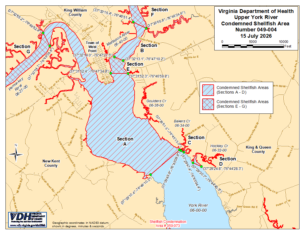
2. Ang Condemned Shellfish Area Number 049-004, na ipinapakita bilang mga Seksiyon A hanggang G, ay itinatatag dito, epektibo sa 15 Hulyo 2026. Tungkol sa mga Seksiyon A hanggang D, ipinagbabawal sa sinumang tao, kompanya, o korporasyon ang kumuha ng lamang tubig na may talukab o kabibe mula sa mga lugar na ito para sa anumang layunin, maliban kung may pahintulot na ipinagkaloob ng Marine Resources Commission, gaya ng itinatadhana sa § 28.2-810 ng Kodigo ng Virginia. Tungkol sa mga Seksiyon E hanggang G, ipinagbabawal sa sinumang tao, kompanya, o korporasyon ang kumuha ng lamang-dagat o kabibe mula sa mga lugar na ito, para sa anumang layunin. Ang mga hangganan ng mga lugar na ito ay ipinapakita sa mapa na pinamagatang “Upper York River, Condemned Shellfish Area Number 049-004, 15 Hulyo 2026” na bahagi ng paunawang ito.
3. Ang Kagawaran ng Kalusugan ay tatanggap, magsusuri, at tutugon sa mga petisyon ng sinumang interesadong tao anumang oras hinggil sa muling pagsasaalang-alang o rebisyon ng kautusang ito.
MGA HANGGANAN NG LUGAR NA KONDEMNADO BILANG 049-004
A. Ang kinondenang lugar ay dapat magsama ng bahaging iyon ng Ilog York at ang mga tributaryo nito sa itaas ng linyang iginuhit sa pagitan ng coordinate ng mapa ng latitude / longitude (37°29'10.4",-76°46'10.2") at coordinate ng mapa (37°29'51.3",-76°45'13.0"); ngunit hindi kasama ang mga lugar na tinukoy bilang Seksyon D, E, F at G.
B. Ang condemned area ay dapat magsama sa bahaging iyon ng Mattaponi River sa itaas ng linyang iginuhit sa pagitan ng coordinate ng mapa ng latitude / longitude (37°32'19.0",-76°47'27.5") at coordinate ng mapa (37°32'13.1",-76°47'10.2"); ngunit hindi kasama ang lugar na tinukoy bilang Seksiyon F.
C. Ang kinondenang lugar ay dapat magsama sa lahat ng Bakers Creek sa itaas ng linyang iginuhit sa pagitan ng coordinate ng mapa ng latitude / longitude (37°29'49.8",-76°45'09.8") at coordinate ng mapa (37°29'47.4",-76°45'04.4").
D. Ang kinondenang lugar ay dapat magsama ng buong Hockley Creek sa itaas ng linyang iginuhit sa pagitan ng coordinate ng mapa ng latitude / longitude (37°29'30.7",-76°44'45.3") at coordinate ng mapa (37°29'24.8",-76°44'28.3").
E. Ang kinondenang lugar ay dapat magsama ng bahaging iyon ng Ilog Mattaponi sa itaas ng linyang iginuhit sa pagitan ng coordinate ng mapa ng latitude / longitude (37°31'52.4",-76°47'34.9") at coordinate ng mapa (37°31'52.3",-76°46'59.8"); ngunit hindi kasama ang mga lugar na tinukoy bilang mga Seksyon B at F.
F. Ang kinondenang lugar ay dapat magsama ng bahaging iyon ng Ilog Mattaponi sa itaas ng linyang iginuhit sa pagitan ng coordinate ng mapa ng latitude / longitude (37°33'15.4",-76°46'51.4") at coordinate ng mapa (37°33'05.8",-76°46'24.6").
G. Ang kinondenang lugar ay dapat magsama ng bahaging iyon ng Pamunkey River sa itaas ng linyang iginuhit sa pagitan ng coordinate ng mapa ng latitude / longitude (37°32'34.7",-76°49'38.8") at coordinate ng mapa (37°32'55.2",-76°49'52.4").